

VEMBAR
Rohini Vembar is one of two M.S. students in Natural Resources & Environmental Sciences who has received funding from the Midwest Climate Adaption Science Center (CASC) team at the University of Illinois. Working with Illinois Natural History Survey (INHS) scientist Suneeti Jog, she has helped create a mapping tool that will assess Midwest wetlands using projected climatic changes expected in these areas. This tool would inform wetland management decisions in determining areas to prioritize protection and conservation.
For a general audience who may not have lots of information about wetland management, why are wetlands and their ecosystems important?
Since they’re at the intersection of terrestrial and aquatic environments, wetlands are influenced by and heavily influence those systems. They’re often referred to as “the kidneys of the Earth” due to their role in nutrient and pollutant filtration. Additionally, they provide natural flood protection by acting as a water catchment.
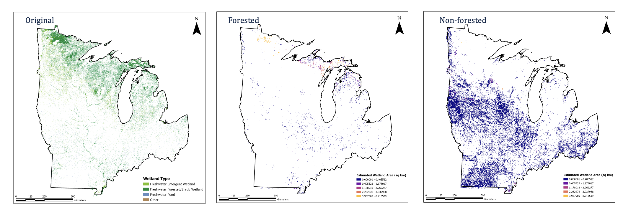
Mapped wetlands in the Midwest from U.S. Fish and Wildlife.
These services that wetlands provide are important for humans but the long history of draining wetlands for farmland have resulted in a significant decline in the services that wetlands provide. Almost 90% of the historical wetlands in Illinois have been drained and are farm fields now. We’ve had to build levees and dams along the Mississippi river and that would not have been needed if the wetlands that buffer the river had been left alone.
In terms of management, federal legislation doesn’t have one rule specific to wetlands. Wetland protections are a culmination of lots of different acts and laws administered by several agencies, making wetland regulation incredibly confusing and constantly up for debate. Part of my work is conducting wetland delineations for the Illinois Department of Transportation. So, when there’s a construction project that has federal or state funding, we go and see what natural resources are there that will be impacted by the project.
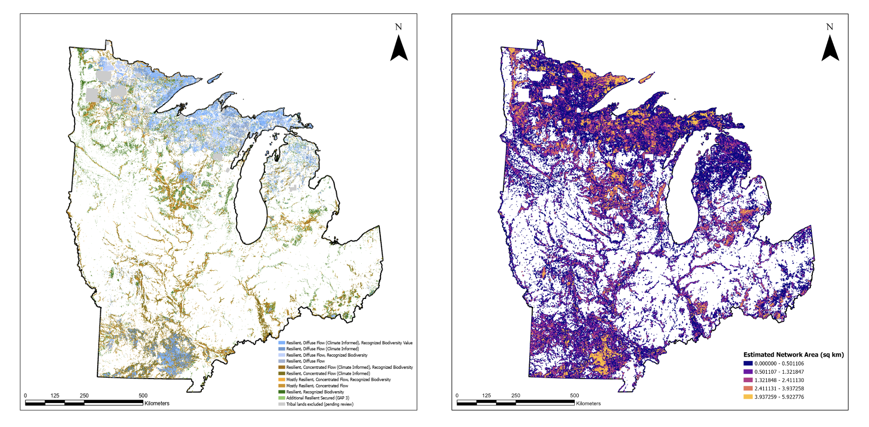
Midwest mapping from the Nature Conservancy’s Resilient and Connected Network.
Your research is on climate change adaptation and mitigation. What kinds of impacts are we seeing currently and what do future projections say about wetlands in a changing climate?
In terms of precipitation, there are some regions that have been a lot wetter, but if you look at Illinois, most of it has been in a drought. When we do get those big occasional rain events, it leads to flooding. What makes wetlands special is that the vegetation has adapted to deal with heavy amounts of water. These plants can survive in a lot of water where other plants would die when you drown them. When a wetland doesn’t get enough rain or water needed to keep up with those plants, they’ll die in a drought. When we do get a big rain event, the root system isn’t there to suck up the water. So instead, the water sits there like a puddle.
Wetlands also act as carbon sinks. When there’s more carbon in the atmosphere, wetlands are able to take up some of that, but there’s a thin line between being a carbon sink and a carbon source. At some point, they will start emitting carbon instead.
Tell me about the mapping tool you’re creating.
I have been working on a mapping tool that highlights areas where wetland protection and management should be prioritized as climate patterns continue to change. It looks at the distribution of wetlands across the Midwest and how they overlap with areas of high landscape resiliency. Landscape resiliency includes the ability for landscapes to perform functions and sustain biodiversity through habitat connectivity as conditions change. Overlaying general distribution of wetland habitat with those areas of interconnectedness will show where wetland protection should be a high priority as the climate changes. Additionally, the inclusion of climate projections shows how and where wetlands are expected to be impacted.
Oftentimes, destruction of wetlands is unavoidable. In instances where wetlands are impacted, federal legislation requires compensation in the form of wetland restoration, creation, or preservation to result in “no net loss.”
However, there is a lot of evidence that restoration and construction of wetlands needs a lot of human intervention after the restoration to maintain the system. They’re not as sustainable as natural wetlands. There is a high probability of new wetlands being overrun with invasive species or needing water to be pumped into it. Of course, restoration is better than nothing, but preservation is the best way to go.
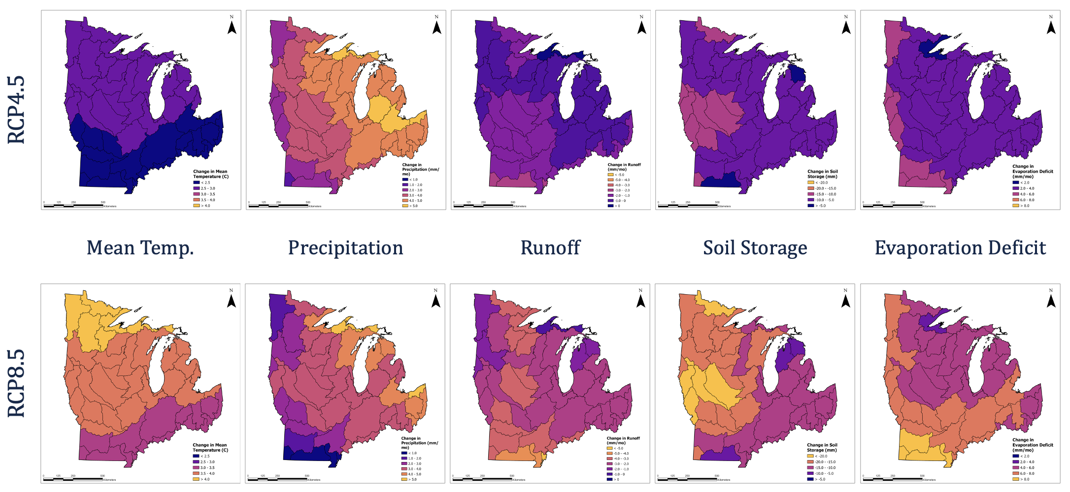
Midwest climate projections for the current carbon emissions trajectory (top) and a worst-case scenario (bottom).
What kind of data is currently used in your model?
First is the U.S Fish and Wildlife Service’s wetland distribution data. Their National Wetlands Inventory shows where wetlands in the country are located. The second data source is the Resilient and Connected Network from the Nature Conservancy. It’s a newer piece of data that was really helpful to my research. The third piece of data is climate projections. I’ve used two different emissions scenarios: The first is RCP 4.5, which is our current carbon emissions trajectory, and RCP 8.5 is a worst-case scenario. This also includes five different climate variables that heavily influence wetlands: mean annual temperature, precipitation, runoff, soil storage (how much water the soil can hold), and evaporation deficit (how much water after precipitation can be evaporated). The goal is to show how these three components influence each other.
How are you hoping this tool will be used?
To give priority to certain wetlands that need protection. With climate change occurring there’s a very real possibility that wetlands will slowly migrate, which raises the question of whether they should be allowed to move to new areas. Larger wetlands with more diversity used to cover the Midwest, historically. In some ways, those are the most productive types of wetlands to have because they perform many different functions and can provide many different services.
Looking into how climate change impacts resilient landscapes should lead to giving information needed to prioritize wetlands and how to manage certain wetlands. If someone is going out to do an assessment, understanding how those wetlands in that area are expected to change can influence management decisions. There are a lot of potential paths for this tool, and it would take years to get it into something that is used regularly, but it’s a step in the right direction. There’s so much written information about these issues, but it’s hard to visualize, and I hope this can help with that.
— Article by iSEE Communications Intern Erin Minor